
Any way the wind blows, the 78th Weather Flight is there
ROBINS AIR FORCE BASE, Ga. — Rain or shine, the 78th Weather Flight — literally — has their head in the clouds, using special technology and techniques to scan for any potential trouble from Mother Nature that could affect base operations and flights in and out of Robins.
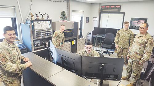
Flight Commander 1st Lt. Nathaniel Donley, Tech. Sgt. Alexander Lopez and Senior Meteorological Technician Roddy Nixon Jr. shared more on the day-to-day operations of the flight. They said this year’s slew of severe weather scares has kept them on their toes and, as a result, kept people on the base safe.
“Our mission here is to provide environmental intelligence to the base, whether that be sending out weather alerts for thunderstorms, heavy rain or lightning for the five nautical miles around the base, or just giving weather briefs to pilots for their flight route if they’re going out of state or if they’re flying around the local area,” Commander Donley said. “We also go and brief the senior leaders here on the base, like the base commander or any other wing commanders here, to give them whatever intelligence we need to for any mission that’s going on, exercises or other things of that nature.”
Lopez said the flight operates under three different sections: the forecasting desk, leadership staff and the training office.
Twelve people in total help to operate the 78th Weather Flight, consisting of a commander, flight chief, two civilians working with training and forecasting, a few junior enlisted personnel and some others that have been serving for a longer period of time.
Nixon said the training process to prepare airmen for forecasting and other similar duties involves a three-phase approach, beginning with about a half-year of training at Keesler Air Force Base in Biloxi, Mississippi.
“During the course of those several months, they basically compress roughly two years worth of college out of the equivalent of what a North Carolina State or Penn State University and their meteorology program [would offer]; that lays the foundation,” Nixon explained. “And then they come here, we fine-tune that to our operations here at Robins Air Force Base as well as our worldwide contingency response mission.”
He added that he, alongside Donley, Lopez and other training personnel around the flight, will then teach trainees all aspects of local climatology, terrain, topography as well as weather features and patterns on a regional and international scale.
Their primary scope of focus at Robins generally pertains to a radius of five nautical miles surrounding the base, but when the interests of Robins are at stake, they can adjust that focus.
“Within that five nautical miles, Sgt. Lopez, for instance, can literally take a dart and hit a bull’s-eye every time he does his forecast,” Nixon said. “Unlike our National Weather Service forecast counterparts, we have a 96-county area — roughly one-third of the state of Georgia — to try to verify the occurrence of a phenomena we have to hit to verify within that five-nautical-mile radius.”
He applauded the young members of the team that help make the flight operate from day to day, explaining more about the task at hand and how much they expect out of those members. The forecast team members are, on average, 22-24 years old.
“It is a huge responsibility that we are putting on these young men and women,” Nixon said. ” … Within that five-nautical-mile radius, we have $8 billion of strategic assets here — some of which are very unique to the United States Air Force — so it is an awesome responsibility.
“The young men and women are very vigilant in their training. We’re always looking for new concepts, new innovations and new techniques to improve our forecast and/or watch, warning and advisory capability.”
Lopez said the forecasting area runs on three different shifts throughout any particular day. When the shifts cycle, the flight undergoes certain procedures as they pass the torch to the relief.
“At the start and end of each shift, we have our forecasters give each other, basically, a handoff briefing: what we call ‘MECO(n)’ [or] ‘meteorological conditions,’” Lopez explained. “That just tells the next person that comes in what to expect weather-wise, mission-wise. If there’s anything currently happening that is pertinent weather-wise, they’ll have that information there, any equipment outages.”
Once the shift begins, the incoming flight personnel will sit down at the desk and try to evaluate and gain a “good situation awareness” of any weather fronts, notifications from the National Weather Service or the Severe Prediction Center, and then develop their forecasts. They call this a “terminal aerodrome forecast” (TAF), a method focused on assisting pilots.
“[TAFs are] something that can be seen globally by all pilots or any weather station, and actually, any civilian, too, can pull up that information from the Aviation Weather Center,” Lopez said.
Another forecast model they work with includes the “mission execution forecast” (MEF), one that Lopez said is more tailored for the local area.
Throughout the shift, the ones at the forecast desk will monitor the weather and issue any watches or warnings deemed necessary to maintain resource protection at Robins.
The flight crew also makes use of a weather radar station in Jeffersonville, a 153-unit setup under a tri-agency operation between the departments of Defense, Commerce and Transportation. Nixon explained that other agencies around the county find ways to make use of the data acquired by radar stations such as this one.
“We all use each other’s radars in order to field a data pool across the lower 48 United States, Alaska, Hawaii and our overseas locations,” Nixon said. “A number of our foreign partners also have WSR 88-D, Doppler radar unit. So, it is a very integral tool, not only to us and those three federal agencies, but in the commercial media as well, because through those agencies, commercial vendors access that data and sell it to broadcast outlets and other significant agencies that have a need for that data.”
Those local to Houston County can’t forget the EF3 tornado touching down in the Bonaire area back in April. Lopez said that particular storm hit within five miles of the base, and he was at the forecast desk that day sending out alerts.
Using a five-day outlook courtesy of the Severe Prediction Center, he said the flight had their eyes on the storm during the days prior.
“So, we were already on a heightened alert mentally and around the shop here,” Lopez said. “We also sent out notifications via email, just giving people a heads-up of any kind of significant weather we were expecting; in this case, we were talking about wind, hail and tornadoes, that being a significant possibility of coming through.”
Once the storm had passed through Mississippi and eventually reached Montgomery, Alabama, the flight team began addressing the situation using “severe weather action protocols” (SWAP).
“We issued the watches and advisories accordingly,” Lopez said. “So, as that band crossed over the Alabama-Georgia line, we were eyeballing a few spots that we felt could track towards us.”
When those storm signatures were seen crossing over I-75, Lopez said the incoming weather met all warning criteria — and they addressed it as such.
“We went ahead and issued the warning, and not to brag, but we did best the National Weather Service by about 15 1/2 minutes lead time, [or] the time before an event occurs,” Lopez said. “The ideal [lead] time for tornadoes is 15 minutes; anything less than that and it’s just not as useful for being prepared.”
Following the sirens, people prepared themselves as the storm “skirted” the five-mile ring surrounding the airbase. Even though the tornado wreaked havoc at the Statham’s Landing neighborhood, there were no deaths that day.
“That was a very eventful, very stressful day, but we hunkered down and we did what we were supposed to do,” Lopez said.
Donley added that since the sirens on base went off before others in the area outside the base, people nearby were alerted even quicker than they would have been by the county sirens.
Nixon said that when he began work with the flight about four years ago, they would have been lucky to receive a three-minute lead time on a storm like the one in April, explaining that their operation has grown “leaps and bounds.”
As for the flight’s “greatest challenge,” Nixon said the swamp located on the east side of the base keeps them on their toes, especially considering this year’s storms and varying weather.
“It’s not just here at Robins, terrain and topography have those impacts anywhere and everywhere in the world,” Nixon said. “For example, I have an advantage over my colleagues of having this station here at Robins, where the swamp is on the east side, and I was also stationed at Lawson Army Airfield at Fort Benning, where the exact same thing is on the west side of that installation.
“So, those [factors] have to definitely be taken into consideration, as we forecast the various phenomena that we will do here. It can impact everything from fog and stratus, to thunderstorms on the fall line here coming through central Georgia [that] can enhance or weaken thunderstorm activity; we have to monitor all of that.”
Donley explained that if bad weather rolls in and the flight considers the safety of the base’s members to be at risk, their unit can play a role in the process behind shutting down access to Robins.
“We provide that information to the installation commander, and then she makes the ultimate decision to stop people from coming on base,” Donley said. “Say, for a tornado warning, if we issue that and it automatically goes out, then everyone on base has their process to shelter in place and get to an interior room in case of tornadoes.”
He added that the 78th Weather Flight also collaborates with other units around the base, including the following: flying wings, the logistics complex, civil engineering and the 53rd Air Traffic Control Squadron, with more to come.
Nixon said, in the past, the flight has worked with other local partners during Severe Weather Awareness Week (Feb. 6-10, 2023) by giving out weather radios and sharing safety knowledge with civic organizations, churches and school groups in the area.
“That mitigation is absolutely critical,” Nixon said. “One of the phrases we use here in the weather flight is, ‘it only takes one occurrence.’
“It only takes one occurrence of a tornado, it only takes one occurrence of a hurricane to dramatically change your life. So, anything we can do to mitigate the impacts associated with the occurrence of those, we are here to provide that information and that system to ensure readiness thereof.”
If anybody in the community is interested in learning more about the work of the 78th Weather Flight and how to stay safe amid dangerous weather, reach out to the Robins Public Affairs Office at (478) 926-2137.
HHJ News
Before you go...
Thanks for reading The Houston Home Journal — we hope this article added to your day.
For over 150 years, Houston Home Journal has been the newspaper of record for Perry, Warner Robins and Centerville. We're excited to expand our online news coverage, while maintaining our twice-weekly print newspaper.
If you like what you see, please consider becoming a member of The Houston Home Journal. We're all in this together, working for a better Warner Robins, Perry and Centerville, and we appreciate and need your support.
Please join the readers like you who help make community journalism possible by joining The Houston Home Journal. Thank you.
- Brieanna Smith, Houston Home Journal managing editor
Paid Posts
Related Articles
Robins’ School Liaison Program: setting students up for success
Ensuring children receive a quality education is vital for families, especially those in the military. At Robins Air Force Base, a special program serves as a beacon of hope, helping families navigate the challenges they face.

Testing… testing…: Robins First Article Test Lab ensures parts make the grade
From concept to construction, aircraft parts undergo a thorough process to ensure they are ready for the fight, including a stop at the First Article Test Lab.
17th Electronic Warfare Squadron welcomes new commander, stands up two detachments
It’s a new era for the warfighter’s approach to electromagnetic technology at Robins Air Force Base, led by three new commanders.